Research Reveals Origins of River, Evolution of Ancient Landscape
December 28, 2020
- Author
- Jay Pfeifer
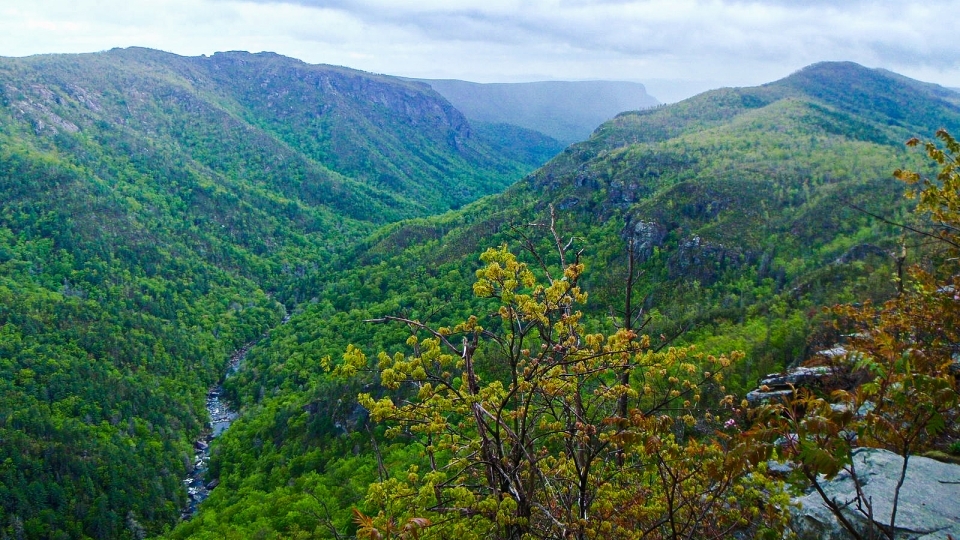
Sometimes referred to as the “Grand Canyon of the Eastern USA,” the Linville Gorge is among western North Carolina’s most scenic attractions.
Faced with a nearly empty campus last spring, Brad Johnson locked himself in his office to pore over maps of Linville Gorge, an unusually steep, rugged canyon among the Blue Ridge Mountains in western North Carolina.
“Given the difficulty of the semester, I was practicing some escapism by doing a deeper dive into one of the more amazing landscapes around,” the geologist said.
The question facing Johnson, chair and associate professor of Environmental Studies, was simple: Why is the Gorge so deep? What makes it so different than other rivers in the area?
While he stared at the maps, Olivia Stanley, an environmental studies major and 2020 graduate, came to him with findings from a research project. Her work transformed how Johnson saw his research.
“I had spent the better part of my last two years at Davidson researching the Gorge,” Stanley said. “In the summer of 2019, with a grant from the Davidson Research Initiative, I walked miles and miles of riverside trails, taking field notes and turning them into a digital mapping of the Linville River and Gorge.”
That map showed that the Linville River starts much farther up in the Blue Ridge than other streams around it, Johnson said. “It looked just like stream profiles in Virginia that we had looked at in class the day before.”
That paper focused on stream capture—the geological phenomenon when water from one stream is diverted into another, steeper stream. The similarity between the captured streams in Virginia and the Linville River seemed to indicate that stream capture might help to explain the unique nature of Linville Gorge.
“At its most simple, it is really a question of which way a river flows,” Johnson said. “Rivers on top of the Blue Ridge Escarpment—the steep section of terrain that leads into the mountains—tend to be slow, meandering rivers that eventually drain toward the Gulf of Mexico. Meanwhile, streams on the face of the Blue Ridge Escarpment are much steeper and drain toward the Atlantic. This creates a situation where the steeper streams that drain east can steal flow from the lazier streams on top.”

This illustration from Johnson’s research shows the phenomenon of stream capture, when water from one stream is diverted into another, steeper stream. Diagram source: Journal of Geomorphology.
Stanley’s profile of the Linville River showed that it is a little of both: It flows both on top of the escarpment before charging down its face. What if the Linville had captured a west-flowing river and diverted the water to the south?
“Essentially, the hypothesis was that the much steeper Linville River was eroding up its slope and captured the headwaters of the North Toe River,” Johnson said. “After the capture, the extra water provided extra erosive energy, which carved the modern Linville Gorge.”
The idea sounded promising. But how could Johnson prove it?
Detective Work
“We ended up getting very lucky,” he said. “Quartzite outcrops exist only to the east of the modern Linville River. If we could find any quartzite boulders to the west of the Linville River, it would show that the river once flowed in a different direction and carried those rocks to the west, which would be impossible today.”
Using some old geologic maps and Google Earth, Johnson found two possible riverbeds that flowed from east to west, bisected in the middle by the modern Linville River flowing south. He could also see large rocks in those ancient streambeds. If any of those boulders were quartzite, it would prove the hypothesis true.
Johnson got in his car and drove two hours into the mountains—careful to minimize interactions during COVID. As he headed to the spots he’d circled on his maps, he noticed that the fields to the side of the road were filled with pumpkin-sized rocks known as cobbles.
“Normally I’d work with landowners to get permission to do detailed sampling,” he said “However, given the complications of interacting with strangers during a pandemic, I decided I needed to do limited sampling along the side of the road.”
Basically, he hopped out of his car, grabbed a couple of easily accessible rocks, and headed back to Davidson.
“Those all turned out to be quartzite,” he said, “remnants from an abandoned stream system.”
His hypothesis was confirmed. Johnson got to work documenting his findings, publishing them very shortly afterward in the in the journal Geomorphology in July.
“Broadly, this helps us to understand how the Blue Ridge Mountains evolve,” Johnson said. “Specifically, it helps us understand why the area is so steep despite being hundreds of millions of years old—because the rivers and streams still act to shape the landscape. That said, sometimes it is just really fun to solve a mystery.”