Davidson College Students Measure Hurricane Helene's Impact on North Carolina's Wilderness
September 26, 2025
- Author
- Jay Pfeifer
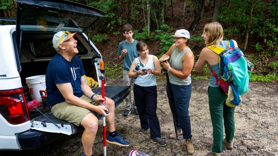
On a hot July morning this past summer, two white pickup trucks left the E. Craig Wall Jr. Academic Center and headed toward Wilson Creek, a river tucked into the Pisgah National Forest.
Two hours later, the trucks crunched to a stop on a gravel road deep in the woods and six students hopped out. They hiked down a trail for about 10 minutes before they paused, looked up a steep slope to the right and unceremoniously stepped into the brush. They climbed uphill over tree trunks and scrambled under branches until they found their quarry: A clearing created by a “blowdown” a cluster of uprooted trees, lying on their sides.
A blowdown is one of the many scars left by Hurricane Helene, the massive storm that passed over Wilson Creek and western North Carolina in late September 2024. The storm’s soaking rains and strong winds flooded rivers, triggered landslides and punched thousands of clearings like this into the forest.
Hurricane Helene was so immense – and the landscape it affected so rugged – that aerial photography, satellite imagery and a host of other data sources do not actually work very well for seeing the impact. Put simply: We know the storm was powerful. But what was the total impact on trees and soil?
That’s a tricky question to answer; there’s only one way to find out.
“You don't really know till you have to climb through all the brush and everything and get out there,” said Anna Farmer ’27.
When Hurricane Helene hit in September 2024, Environmental Studies professor Brad Johnson tossed his syllabus so he and his students could study the impact of the historic storm. A year later, Johnson’s students have grown into seasoned researchers and close friends. Join them on a day in the mountains as they study blowdowns and reflect on their experience in the field.
The students had chosen this blowdown spot by studying aerial photographs back on campus. On the screen, it looked like a speck of brown among the green canopy. Here, it was a sudden, gaping opening that left them baking in the sun.
Working quickly, a team of three students swarmed the “root ball,” measuring the width of the tree’s exposed base. Then they stretched the measuring tape to check the depth of the crater that formed when the tree fell. Using a high-resolution GPS plotter, they recorded the location of the felled tree and, using the compass app, they held their phone against the tree trunk to note the direction the tree had fallen. The process took less than five minutes and yielded a handful of data points.
This data – from one tree – might not tell them much about Helene’s effect on this area, but these students have measured and recorded hundreds of fallen trees since the storm hit the area.
“By looking at these trees, we're trying to figure out if there's a pattern in the direction that they fell; if they fell down the slope or up the slope,” Neve Rauscher ’26 said. “We're trying to figure out what slope, angle, the trees that blew down were on, and also the direction of the slope.”
This small group of Davidson students has spent hundreds of hours in the field trying to measure just how a storm like Helene changed the water and soil of Wilson Creek. By studying this one small sliver of western North Carolina, they may gain insight into how storms affect terrain more broadly.


“This data will allow us to see how powerful hurricanes are and, in different parts of this area, where they were the most powerful,” Susanna Payne ’27 said. “Hopefully we can predict or know how powerful this storm was and compare it to storms that have happened in the past and storms that will happen in the future.”
A New Course
Last September, before Helene made landfall on the Florida coast, the mountains in western North Carolina had been soaked by a stalled front. When the storm passed, some rain gauges showed the area had received over 24 inches of rain in just a couple of days. The damage was truly catastrophic.
As Brad Johnson, environmental studies professor and geomorphologist, watched the news, he saw an opportunity to help and to give his students in “Intro to Geomorphology” a chance to study their subject in real time.
“I pulled the plug on the syllabus,” he said.
The storm flooded the mountains on Thursday and Friday. When the class next met on Monday, he brought aerial photos of the region and taught them to search for tell-tale signs of landslides. As the fall wore on, the situation in Western North Carolina improved to the point where Johnson could take students to a few select sites where he had personal relationships.
By the spring semester, the idea had grown into an entirely new course. Johnson had planned to teach an elective course in the spring but scrapped it, replacing it with “ENV 325: Landslides in the Blue Ridge” so they could focus on studying the effects of Helene on Wilson Creek. The class would be small – only 12 students – and the work would be demanding.
“Any student that wanted to take that class had to guarantee to me that they would go up to the mountains with me on five Friday afternoons for the whole afternoon,” Johnson said. They would leave campus at lunch time and return after dark.
What they saw in those early field days in the spring was unimaginable. Mangled RVs sat in the riverbed. Log jams piled three stories high signaled the height of the Helene-flooded waters. Even the river itself had changed. It flowed through new channels over fresh fields of cobbles carried by the raging water.
Johnson and his students got to work, measuring what they could.
“I feel like in order to better understand how these hurricanes affect these systems, we have to just catalog everything,” Johnson said. “So data collection in the short term is really important, and then we can start to make sense of it long term.”


The class originated with a focus on landslides but quickly grew to encompass a handful of specific research subjects. Johnson divided the class into five teams that studied soil composition and tree populations affected by landslides, peak water discharge on Wilson Creek, logjam locations and composition and of course, they hunted and measured blowdowns.
This was hard, sweaty work.
Torin Linton ’26 and Bailey Scarlett ’25 scrambled under, over and around countless rhododendrons so they could tag and count trees on a hillside. By establishing a baseline number of trees per acre, they could then estimate just how many trees had been carried away in the thousands of landslides Helene had jarred. Farmer and Payne stretched measuring tapes across Wilson Creek to estimate how wide the river got when it was swollen with Helene’s rain.
Their semester of study produced results, but they had a lot of work left to do. Many of the ENV 325 students extended their research, staying on campus over the summer to continue.
By late summer, this group of neophyte geologists had grown into a team of nine seasoned scientists.
“All these students have almost a whole year’s worth of field work by the end of this, doing work on Helene,” Johnson said.
Davidson students involved in the project have also worked with a variety of faculty (and potential graduate advisors) from other universities.
“Since we were already working in the area, we had really good land access. It has been deeply satisfying to help others who want to study Helene by showing them our field sites. Then, it allows us to all work together to push the science forward in collaboration,” Johnson said.
Anna Marshall, a geomorphologist at the University of Tennessee, visited the team over the summer and found a group of talented collaborators.
“We learned a lot from each other,” she said. “In fact, I probably learned more from them. They had a system; they had thought through their methods.”
Marshall and Tennessee students are doing similar research on a river closer to Knoxville.
“Often at big R1 institutions, like Tennessee, this kind of in-depth and independent research experience is pursued at the graduate level,” she said.
Brad’s students have such a leg-up. They have developed technical skills but they also have incredibly valuable skills that include learning how to communicate their work and their research. Those skills translate to any undertaking after graduation.
Geomorphologist at the University of Tennessee
Johnson’s students built deep friendships while developing those skills.
“Some of these days are nine or 10 hour days.You're scrambling over logs, you're in the creek, you're in and out of the creek,” he said. “It just makes it so much easier if you're enjoying the time and you're spending it with people you like.”
The students who stayed on for summer frequently skipped the commute back to campus and overnighted in a 900 square-foot cabin near the creek where they played wiffleball games with neighbors on a wide field next to Wilson Creek. Back in Charlotte, they capped days in the lab by going to minor league baseball games.
“You get to know people pretty well just by hiking on a trail without any cell service,” Rauscher said. “You just get to talking and ridiculous things happen. Someone will forget their sandwich and you're sharing food, or you're all trying to read a map and you really don't know which way is which.
“Through the humor and the times we've spent together, we've gotten pretty close.”


Real-World Problems
In mid-July, they were reminded of the relevance and urgency of their work when floods in the Texas Hill Country claimed over 100 lives. Johnson’s students picked up clear echoes of what they had seen in Wilson Creek.
“I came in and the first thing they wanted to ask me about was Texas,” Johnson said.
“Once you see the news and you see images of flooding and areas where people really do suffer from things like this, it does give you a sense of purpose and a reason why you're doing it,” Payne said. “And that definitely pushes you forward.”
The students have studied the challenge of climate change and they also see the opportunity to help communities prepare for an era of increasing environmental hazards.
“Natural disasters are becoming more and more common, and so I think there's a big field opening up in terms of natural disaster research and recovery,” Rauscher said.
She hopes the work will feed directly into post-graduate work.
“Davidson students are interested in the world around them,” Johnson said. “Environmental studies is not simply a science degree. It's an interdisciplinary degree and the students want to apply it to other things as well.
“It's satisfying to see them connect those dots,” he said. “And also not surprising, because this is what they're trained to do.”